An Urban Hike through South Carolina’s Oldest Neighborhoods
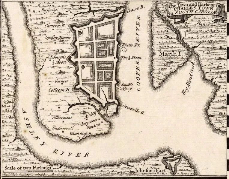
In 1670, British settlers sailed up the Ashley River and established “Charles Towne” named for King Charles II. Ten years later, the pioneering settlement was moved 4 miles southeast to the confluence of the Ashley and Cooper Rivers. The initial development plan consisted of a simple network of three north-south streets (Meeting, Church and Bay) and three east-west streets (Queen, Broad and Tradd) that intersected to form four large blocks on 34 acres. Over the next two decades, the north-south streets were extended and new streets were cut through the blocks. Walls were built at the end of the 17th century to protect the 62-acre city from the threat of French and Spanish invaders.
Urban expansion and storm damage led to the dismantling of most of the walls by the 1730s. The city’s eastern walls along the Cooper River were maintained until threats of invasion subsided in 1783 after the War for American Independence.
Cumberland and Water Streets (and part of Meeting Street) mark where the northern, southern, and western walls once stood. East Bay Street was the location of the eastern wall.
The old walled city, along with its 18th-century annexations, feels like a medieval European city with a tropical flair. This 5-mile hike winds through 220 acres of historic neighborhoods. At a leisurely pace, expect to complete the route in 2–3 hours while passing some of the finest architecture in the United States.
Starting Point
Parking: If you aren’t staying within walking distance, convenient parking is available at the Cumberland Garage at 90 Cumberland Street.
Landmark: Across the street from the parking garage is the Old Powder Magazine (1713) at 79 Cumberland Street. South Carolina’s oldest public building features thick masonry walls and a pantile roof.
Follow along on Google Maps and use the directions below for a step-by-step guide and tour highlights.
Route Directions
From the garage, proceed east, cross Church Street, then turn right on East Bay Street.
Go three blocks, then left on Vendue Range toward the Cooper River and the fountain at Waterfront Park.
Pass the fountain and examine the bronze maps at the water’s edge.
Turn right onto the path along the Cooper River.
The path intersects with Concord Street – cross and go west on Exchange Street.
Two blocks later, turn right on East Bay Street.
You’ll see the Old Exchange Building (1771–72) on your right – the site of many historic events including South Carolina’s convention to ratify the U.S. Constitution in 1788. The basement houses a museum where a section of the original city walls can be seen.
Proceed north to Cordes Street, cross East Bay, and go west on Unity Alley until it ends at State Street.
Turn left on State Street, cross Broad Street, and before proceeding.
Turn to look back across the street at the People’s Building at 18 Broad Street. Constructed in 1910-1911 at a cost of $300,000 (about $10 million in 2025 dollars), the People’s Building is considered Charleston’s first “skyscraper.”
Exploring Charleston’s Hidden Lanes and Landmarks
Proceed one block west on Broad, then left on Church Street.
Go one block, then left on Elliott Street.
After two blocks, turn right on East Bay Street. The colorful townhomes on the right on the next two blocks comprise “Rainbow Row.”
Turn right on Tradd Street for two blocks, then left on Church Street.
Turn left on Longitude Lane (a narrow pedestrian lane— don’t miss it!).
Turn right on East Bay Street (Note: there is a public restroom available across the street.)
Turn right on Stoll’s Alley (a very narrow pedestrian lane marked by a street sign—don’t miss it.) Thoroughfares like Unity Alley, Longitude Lane, and Stoll’s Alley were not part of the original street plan, but emerged from footpaths, which were later paved in brick, slate, and cobblestone.
Turn left on Church Street for one block, then left on Water Street.
The Historic Battery and White Point Garden
As you walk east toward the Cooper River on Water Street, try to imagine earthen and stone walls that once extended down the left-hand side of this street. For most of the 18th century, Water Street was known as Vanderhorst’s Creek because it was in fact a navigable saltwater creek, which provided access by boat. In the 1750’s the City’s eastern walls were continued southward and a flood gate built at the mouth of Vanderhorst’s Creek. This flood gate controlled the water flow, turning the creek into a canal. Charleston’s City Council passed an ordinance in 1785 to extend East Bay Street to White Point Garden. It was during this period that Vanderhorst’s Creek was gradually filled in, and became Water Street.
Cross East Bay Street and walk up the stairs going right on the elevated sidewalk adjacent to the Cooper River waterfront, known as “the Battery.”
Continue along East Battery Street to its intersection with Murray Boulevard at the confluence of the Ashley and Cooper Rivers.
View Fort Sumter to the East-Southeast (approx. 3 miles out). Beyond it is the Atlantic Ocean. As the old saying goes, “Charleston is located where the Ashley and Cooper Rivers meet to form the Atlantic Ocean.”
Walk about 400 feet west, cross Murray Blvd at the first crosswalk, and head north to the large gazebo in “White Point Garden.” A tremendous bank of oyster shells when the British arrived in 1670, the area was once an execution grounds for pirates and other criminals. Today, the 6-acre park is among the most beautiful and romantic settings in America. It’s worth exploring the park’snumerous monuments and historic markers, or just lingering on a bench under the live oak trees. Warning: Night Herons nest in the live oak branches. Avoid sitting under a nest!
Meandering Through Historic Streets
From the gazebo, head north, then left on South Battery Street. Walk one block, then take a right heading north on King Street.
Left on Lamboll Street. One more block, then go right heading north on Legare (pronounced “Le-gree”) Street.
At one time Legare Street comprised the western frontier of the city. Its charms include enormous live oaks growing out of the pavement, and a right-of-way that deflects at Gibbes Street and again at Tradd Street. Legare widens and narrows along its course, providing an informal elegance that compliments the grandeur of the gracious mansions alongside.
Cross Tradd Street (the street jogs to the left, but is still Legare), then continue for one more block, taking a right turn on Broad Street.
One block, then right on Orange Street.
One block, then left on Tradd, then right on King Street.
Two blocks, then left on Ladson Street.
At the end, right on Meeting Street, which will lead you back to South Battery Drive and White Point Garden.
Final Highlights
Turn left on South Battery for one block, then left heading north on Church Street.
After two blocks, left on Water Street for one block, then right on Meeting Street.
Walk two blocks then right, heading east down the narrow alley called “Ropemakers Lane.” Ropemakers Lane winds its way into a grassy parking lot. Continue east through the parking lot and look for a gate. The gate marks a public path. Open and walk through to Church Street.
Left on Church Street and take your first left on St. Michael’s Alley.
One block, then right on Meeting Street to Broad Street. This intersection is known as the Four Corners of Law: Federal Courthouse, County Courthouse, City Hall, St. Michael’s Church (God’s law). Note: there are public restrooms on the ground floor of City Hall. If you have time, go up to the third floor to check out Charleston’s City Council Chambers.
Cross to north side of Broad Street, head east past City Hall.
Enter Washington Square, proceeding north around the statue to Chalmers Street, then turn right on Chalmers Street.
Take first left back onto Church Street. You will pass two more Charleston landmarks – Dock Street Theatre on your left and the French Huguenot Church across the street on your right.
Turn left on Queen Street for two blocks, then right on King Street.
Two blocks, then right on Market Street, crossing Meeting Street beside Market Hall (you’ll be on South Market Street at this point).
One block, then right on Church Street, then right on Cumberland Street back to the Powder Magazine.
Congratulations!
You have just traversed some of the most resilient urban fabric in North America. You passed more than 1,000 structures – apartments, houses, condominiums, offices, court houses, restaurants, museums, theatres, churches, schools, club houses, as well as cemeteries, monuments, and parks – all located on about 220 acres - area equivalent in size to the Old City of Jerusalem or Florence, Italy during the Renaissance. South Carolina’s oldest neighborhoods took shape in the 17th century, survived plagues, hurricanes, war sieges, and a major earthquake, and still flourish today. I hope you found the journey rewarding.
“All of us, if we are reasonably comfortable, healthy, and safe, owe immense debts to the past. There is no way, of course, to repay the past. We can only repay those debts by making gifts to the future.”
— Jane Jacobs
Some Favorite Places for Libations Along the Route
East Bay Street
High Cotton
Slightly North of Broad
Market Pavilion Hotel Rooftop Bar
Vendue Range
Rooftop Bar at Vendue Inn
Broad Street
Blind Tiger Pub (try courtyard in back)
Oak Steakhouse
Sorelle (the Mercato inside has light breakfast/lunch items)
Meeting Street
The Mills House Hotel Bar
Eli’s Table
Queen Street
Husk (plus adjacent standalone bar)
Harken Café
King Street
Bin 152
Charleston Grill (brunch + jazz)
North Market Street
Peninsula Grill
The Spectator Hotel Bar
Church Street
Goat, Sheep, Cow (ideal stop for White Point Garden picnic supplies)